Regional spatial planning
Regional spatial planning is long-term, strategic planning for how land will be used in a region.144 It gives infrastructure and planning institutions the means to engage and collaborate with each other, mana whenua, the private sector and communities. Spatial planning brings together key public services, physical and non-physical, across a defined area to identify how to respond to long-term service-delivery needs. While spatial planning can occur at a national or local scale, it’s usefully applied at the regional level. Sound governance arrangements are needed for it to succeed.
Spatial planning is an opportunity to rethink how we plan infrastructure and services to keep pace with future population and economic growth. It uses ‘place’ as a framework for integrating and aligning infrastructure service provision.145 Achieving it requires infrastructure providers, land-use planners and other stakeholders to develop shared frameworks for how cities and regions should grow and change over time. Spatial planning should cover issues like how we’ll open up opportunities for homes and businesses to be built, how we’ll meet the needs of future residents with infrastructure networks and social infrastructure like schools, parks and hospitals and how we’ll manage natural hazards and protect areas with environmental or cultural significance.
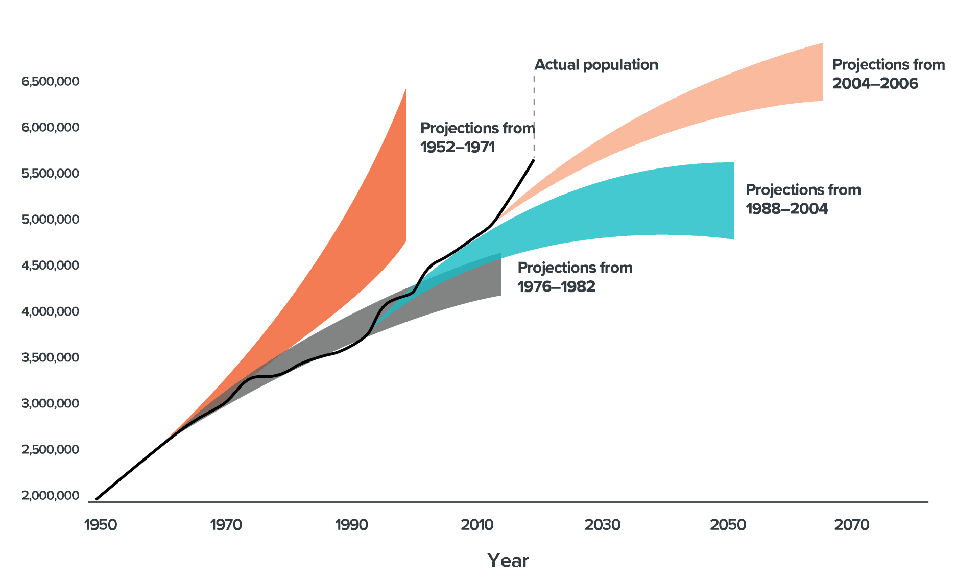
Good spatial planning allows for a range of futures over an extended timeframe, such as future with faster-than-expected growth that could result in a city’s population doubling or tripling in the long-term.146 It addresses housing supply and affordability, manages pressure on infrastructure and provides for future economic activity and export activity, as well as rural lifestyles, particularly in regional areas. Spatial plans should avoid prescriptive rules about where people will live and work, in favour of taking a long-term view to identify, develop and build agreement on significant region-shaping future projects.147 A spatial plan does not sit in isolation. It requires a range of supporting planning documents that are consistent with the plan, including district plans and infrastructure funding plans.
History shows that identifying and protecting future infrastructure networks is a crucial part of regional spatial planning. For example, the 1811 Commissioners’ plan for New York City set out the street grid for all of Manhattan at a time when only a small portion was inhabited. That street grid is still used today. Barcelona’s Cerdà plan looked at how the city could expand beyond its medieval city walls,148 while Copenhagen’s 1947 Finger Plan149 laid out future transport networks and regional parks that have accommodated significant growth. These plans have adapted well to economic and population changes, of which some couldn’t have been anticipated when they were first developed.150 For example, allowing for wide, straight roads made it easy to build subway systems in New York and Barcelona.
Spatial planning should use a depth of evidence and data to inform regional growth and provides opportunities to apply new smart-city technologies. It should be supported by good information on how much growth infrastructure networks can manage and options for upgrading them. Digital twins can be applied to spatial planning to bring real-time data on asset condition and usage into the planning process and establish consistent data standards across regional spatial plans to ensure comparability throughout New Zealand.